|
Issued: 1000 Wednesday 31st October 2018
Duty forecaster: David Hulse
All areas seeing some rain.
A generally unsettled weather pattern with low pressure dominating, the associated frontal troughs bringing spells of rain. A windy start to the weekend in the north and west.
 For the weather for the next few days click here For the weather for the next few days click here
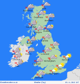
 Saturday 03/11/18 Saturday 03/11/18
A deep low to the southwest of Iceland, tracking east-northeast, will drive frontal troughs into Britain and Ireland. Rain or drizzle, some heavy, over Scotland and Ireland will spread slowly east into England and Wales but central and eastern areas will stay mostly dry. Drier weather with just a few drizzly outbreaks in the west follows into Scotland and Ireland. Possible overnight mist or fog for parts of England and Wales. Strong south or southwest winds across northern and western areas, reaching gale, perhaps occasionally severe gale force in exposed locations. Highs 11 to 15C.
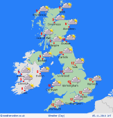 Sunday 04/11/18 Sunday 04/11/18
Low pressure to the northwest of Scotland will move northeast and start to fill, with a new shallow low becoming centred to the south of Ireland; associated frontal troughs will affect Britain and Ireland. Confidence in distribution of rain lowering. Further rain or drizzle, but with some spells of dry and brighter weather developing. However, rain may become heavier and more persistent over Ireland later. Possible overnight mist or fog for parts of England and Wales. Windy in the north and west at first. Highs 11 to 15C.
Monday 05/11/18
Low pressure to the south of Ireland will fill, whilst a large, complex low will start to move east from mid-Atlantic, with frontal troughs into western areas later. Areas of rain or drizzle moving north and east but with drier and brighter spells in between. Highs 8 to 11C in the north, 11 to 13C in the south.
Tuesday 06/11/18
A large, complex low will pivot around the mid-Atlantic, with frontal troughs moving east across Ireland and into the British Isles. A few drizzly outbreaks at first but with a spell of dry and brighter weather developing before rain, some heavy, already into Ireland starts to move east. Highs 8 to 11C in the north, 12 to 15C in the south.
Wednesday 07/11/18
Pressure remains low to the west of Ireland with frontal troughs continuing to affect the British Isles. Outbreaks of rain or drizzle, perhaps most persistent around coasts and hills in the west but with some dry and brighter spells developing. Highs 11 to 14C.
Thursday 08/11/18
Low pressure to the west of Ireland, moving only very slowly east, will drive frontal troughs north and east across Britain and Ireland. Little change to the unsettled weather, with further rain at times. Highs 9 to 14C.
|
