|
Issued: 0900 Monday 26th February 2018
Duty forecaster: Dr. Simon Keeling
Bitterly cold, snow for many, possibly milder in the far south later
Bitterly cold through the remainder of this week. There will be snow at times, most in the east at first but then transferring to more central and southern areas of the UK and Ireland into the late part of the week and weekend. Staying cold in Scotland through the weekend, but some milder weather may start to edge back into the far south.
 For the weather for the next few days click here For the weather for the next few days click here
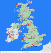
Thursday 1/3/18
A continuing very cold easterly wind affecting all parts of the UK and Ireland. A severe wind chill. Snow in north-eastern Britain, also eastern parts of Ireland. Risk belts of snow also clipping south-west England. Central England and Wales may be dry and brighter with hazy sun. Staying near or below freezing throughout the day. Highs at 0 to -3C.
 Friday 2/3/18 Friday 2/3/18
Low pressure to the southwest of Ireland on Friday. A front brings cloud and sleet and snow through Ireland, Wales, central and southern England. Misty and murky conditions moving into the far south. Cold in northern areas with some snow showers in eastern Scotland and the far northeast of England. Drier to the west. Highs at a cold 0 to -2C for most, 2C in the far southwest.
 Saturday 3/3/18 Saturday 3/3/18
Low pressure to the west and south of the country through Saturday. Bitterly cold air remains in Scotland and northern England as well as Ireland. A risk of snow across Ireland, northern England, Wales and the the Midlands, perhaps into southern Scotland. Possibly milder in the far south of England although misty and murky here. Snow showers in eastern Scotland but drier to the west. Highs at 1C in Scotland, 8C in the far south of England.
Sunday 4/3/18
Pressure stays low through Sunday. A front over Northern Ireland and southern Scotland as well as the far north of England brings the threat of some snow here. Perhaps turning a little brighter to the south and milder here too. Remaining bitterly cold in northern Scotland. Highs at 8C in southern England, 0C in northern Scotland.
Monday 5/3/18
Low pressure may bring further rain, sleet and snow through southern areas iof the Uk on Monday. Some snow showers over eastern parts of Scotland. Tending to be drier and brighter to the west. Highs at 8C in the southeast, 1C in northern Scotland, mainly 2 to 5C.
Tuesday 6/3/18
Low pressure remains in control on Tuesday. This brings a day of sunshine and scattered showers. The risk of more persistent rain or sleet on eastern coasts and hills. Highs at 3 to 7C.
|
