|
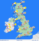
 Tuesday Tuesday
A rather cloudy day across central and southern England as well as Wales with some patchy rain about, possibly turning heavy for a time across far southern counties later. Dry and fine further north and west with good spells of sunshine and climbing temperatures, although there is a shower risk for northwest England and southwest Scotland. Highs at 21 to 26C across Scotland, northern England, Ireland and Northern Ireland, though between 17 and 21C across central/southern England and Wales.
 Tuesday Night Tuesday Night
Some patchy rain may continue to affect southeastern parts of England overnight. Dry elsewhere although cloud looks to thicken across central and eastern areas through the early hour, potentially drawing in some light rian/drizzle onto eastern coasts. Clear spells across Ireland, Northern Ireland, Wales and western areas of Britain. Lows at at 8 to 12C.
 Wednesday Wednesday
Cloudier skies will affect eastern coasts on Wednesday, bringing the risk of some light rain and drizzle that could last through much of the day for some. Further west there will be good spells of sunshine and feeling warm, but with the risk of shower development. Highs at 19 to 25C in the west, cooler further east where there could be more cloud.
 Thursday Thursday
High pressure is the main weather feature on Thursday with plenty of dry weather about, however, relatively widespread developing showers pose a risk across southwest England, Wales, Ireland and Northern Ireland. There looks to also be rather a lot of cloud for many with the best of the sunshine developing later across Scotland and northern England. Highs at a muggy 20 to 25C.
|
