|
 Wednesday Wednesday
Low pressure ot the north of Scotland on Wednesday. A strong west to northwest flow gives cool conditions with some showery rain through the Midlands, southern and eastern areas at first. Gales may affect northern and western Scotland. Showers to the north and west turning wintry on the hills as colder weather arrives. The afternoon is bright with sunny spells. Only passing showers in central and eastern areas, but wintry showers to the north and west. Highs at 4 to 8C.
 Wednesday Night Wednesday Night
A cold and breezy night. There will be showers across many northern and western areas, some of them heavy and falling as sleet and snow on the hills. Drier in the south and east with some clearer skies. More persistent snow may affect central and northern Scotland with blizzard conditions for some later. Lows near 0 to 3C.
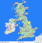 Thursday Thursday
Low pressure to the east of the Uk on Thursday. This is going to bring a chilly and breezy day with a mix of sunshine and showers. Most of the showers will be in northern and western parts of Scotland and England as well as Ireland and Wales. The showers falling as sleet and snow at times, mainly to the north and west. Snow could be heavy over Scottish hills. Feeling very cold in the wind which will be to gale force in Scotland. Highs at 4 to 7C.
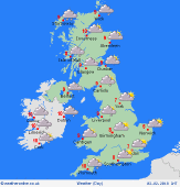 Friday Friday
Low pressure to the north of Scotland on Friday pushes fronts eastwards. These will be bringing cloud, drizzle and light rain, most through Scotland and northwest England later in the day. Generally drier in the east with some brighter weather here. Highs at 6 to 8C.
|
