|
 Sunday Sunday
A front advances slowly north-eastwards, bringing outbreaks of rain, most persistent toward the west & south-west, becoming more extensive across Britain through the day. Rainfall amounts fairly small, least in the east & north-east. Northern Scotland stays dry all day. Brisk southerly winds, especially around western coasts. Sunshine in eastern areas in the morning but clouding over. Highs 12 to 15C north & west. South-eastern areas up to 17C.
 Sunday night Sunday night
Areas of rain continue to drift northwards overnight, mainly affecting west & south-west Scotland and Northern Ireland, locally heavy for a time, but tending to break up. Becoming dry across England and Wales with skies clearing. A breezy night for many, south-westerly winds strongest near western coasts, but dropping lighter in south-east England. Lowest temperatures 5 to 8C.
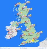
 Monday Monday
High pressure to the south-east and deep low pressure over the Atlantic. Fairly cloudy skies for west and northern areas, with localised showers, mainly Scotland. Otherwise a bright day across the Midlands and south, with sunny spells. Brisk southerly winds for Ireland and western Britain, lighter winds toward the east. Fronts bring rain to western Ireland, turning heavy, later extending to western Scotland. Highs 13 to 18C, warmest south-east.
 Tuesday Tuesday
A strong southerly airflow affects Britain and Ireland. Strongest winds in the west and north. Fronts to the west bring rain to Ireland and western Scotland - heavy and persistent for a time, but tending to fade. Patchy rain elsewhere for western fringes of Britain, murky around some western coasts. Central and eastern regions will be dry, feeling warm in sunshine for the south and east. Highs 12 to 15C north & west, 16 to 19C south-east.
|
