|
Issued: 0530hrs Friday 3rd February 2017
Duty forecaster: Garry Nicholson
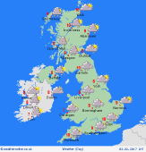 Dry with some sunshine in east & north Dry with some sunshine in east & north
Good morning,
A deep area of low pressure is centred north-west of the British Isles today, whilst a small but active secondary low moves quickly into the south-west.
A frontal zone spreads north across Wales and the south-west, bringing heavy rain for many hours, turning increasingly to snow over the hills. By evening, rain reaches northern Britain, heaviest in north-west England, later southern Scotland. Over the hills, snow may fall to around 200-300m.
Much of east & northern Britain stays dry most of daylight, with some sunshine and fairly light winds.
Gales affect English Channel coasts, gusting 50-60mph or locally stronger around exposed coasts and headlands. Inland across southern counties, winds will gust 40 to locally 50mph. Gales also affect western Scotland. Blustery winds will advance northwards across central-eastern counties into the evening.
Today's top temperatures will be 6 to 9C, dropping to 1 to 4C tonight.
Have a great day.
Garry
|
