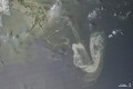
Oil Slick in the Gulf of Mexico
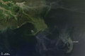
An image from the Moderate Resolution Imaging Spectroradiometer (MODIS) on NASA's Aqua satellite on Tuesday afternoon, May 11, shows that the damaged Deepwater Horizon oil well continued to leak significant amounts of oil in the Gulf of Mexico.

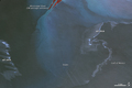
© Image from NASA's Terra satellite - courtesy of the NASA EO-1 team
Oil slicks become most visible in photo-like satellite images when they appear in a swath of the image called the sunglint region-where the mirror-like reflection of the Sun is blurred by ocean waves into a washed-out strip of brightness. In these cases, the difference between the oil-smoothed water and rougher surface of the clean water is enhanced. The slick appears as a silvery-gray patch in the center of the image. The tip of the Mississippi Delta is at upper left. Wispy clouds make it hard to determine whether any of the streamers or smaller patches of oil extend northeast of the main slick.
© Earth Observatory
Oil spill
-

May 17 2010
Oil Slick in the Gulf of Mexico
-

May 11 2010
Oil Slick in the Gulf of Mexico
-
May 10 2010
Oil Slick in the Gulf of Mexico
-
May 09 2010
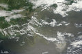
Oil Spill Continues in Gulf of Mexico
-
May 08 2010
Oil Slick near the Mouth of the Mississippi
-
May 08 2010
Oil Slick in Gulf of Mexico